- News
- Sport
- Politics
- Sci/Tech
- Showbiz
- Health
- Business
- Art
- Fashion
- Education
- Weather
- Automotive
- Aviation
- Religious
- Crime
1 image
Kediet ej Jill
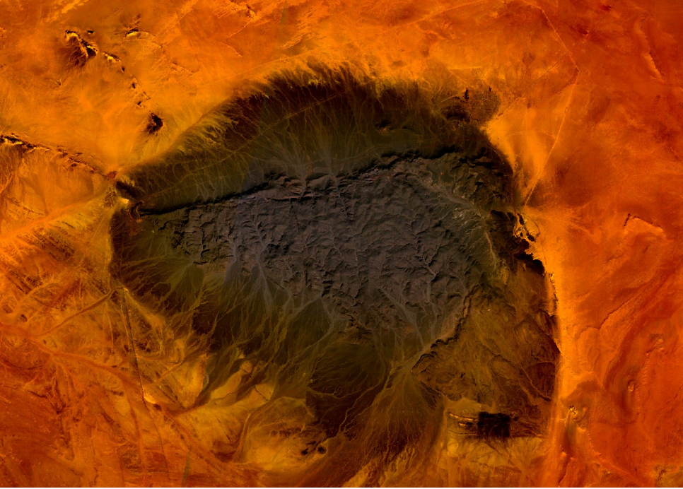
Kediet ej Jill (Arabic: ???????? ????????) is a mountain in Tiris Zemmour, Mauritania, with the city of Zou??rat on its east and Fderick at west. Geography At 915 m (3,002 ft) tall, Kediet ej Jill includes the highest peak in Mauritania. The mountain and its surrounding area are rich in iron deposits, thought to have been mined here since the 11th century and commercially exploited since 1952. The mines are connected to Nouadhibou on the Atlantic coast by a 700 km railway. Geology The mountain appears bluish because of the high concentration of magnetite, an iron ore and naturally magnetic. Owing to its inherent magnetic properties, the mountain disrupts navigational compasses. Similar magnetic fields allowed the discovery of other deposits in the region (magnetite guelbs) in the 1960s. Environment Ephemeral watercourses...
e: 2000000000000009826
Strings (13)
-
str_k__gdb_image
str.gdb:imagehttps://upload.wikimedia.org/wikipedia/commons/0/08/Kediet_Ijill_satellite_photo.png -
str_html_meta_format_detection
str.html:meta.format-detectiontelephone=no -
str_html_meta_generator
str.html:meta.generatorMediaWiki 1.44.0-wmf.8 -
str_html_meta_og_image
str.html:meta.og:imagehttps://upload.wikimedia.org/wikipedia/commons/0/08/Kediet_Ijill_satellite_photo.png -
str_html_meta_og_image_height
str.html:meta.og:image:height860 -
str_html_meta_og_image_width
str.html:meta.og:image:width1200 -
str_html_meta_og_title
str.html:meta.og:titleKediet ej Jill - Wikipedia -
str_html_meta_og_type
str.html:meta.og:typewebsite -
str_html_meta_referrer
str.html:meta.referrerorigin -
str_html_meta_robots
str.html:meta.robotsmax-image-preview:standard -
str_html_meta_viewport
str.html:meta.viewportwidth=1120 -
str_k__rdfs_comment
str.rdfs:commentKediet ej Jill (Arabic: ???????? ????????) is a mountain in Tiris Zemmour, Mauritania, with the city of Zou??rat on its east and Fderick at west. Geography At 915 m (3,002 ft) tall, Kediet ej Jill includes the highest peak in Mauritania. The mountain and its surrounding area are rich in iron deposits, thought to have been mined here since the 11th century and commercially exploited since 1952. The mines are connected to Nouadhibou on the Atlantic coast by a 700 km railway. Geology The mountain appears bluish because of the high concentration of magnetite, an iron ore and naturally magnetic. Owing to its inherent magnetic properties, the mountain disrupts navigational compasses. Similar magnetic fields allowed the discovery of other deposits in the region (magnetite guelbs) in the 1960s. Environment Ephemeral watercourses... -
str_k__rdfs_label
str.rdfs:labelKediet ej Jill