- News
- Sport
- Politics
- Sci/Tech
- Showbiz
- Health
- Business
- Art
- Fashion
- Education
- Weather
- Automotive
- Aviation
- Religious
- Crime
1 image
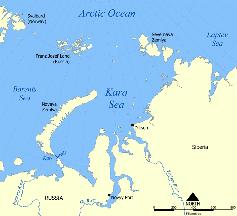
Kara Sea
The Kara Sea is a marginal sea, separated from the Barents Sea to the west by the Kara Strait and Novaya Zemlya, and from the Laptev Sea to the east by the Severnaya Zemlya archipelago. Ultimately the Kara, Barents and Laptev Seas are all extensions of the Arctic Ocean north of Siberia. The Kara Sea's northern limit is marked geographically by a line running from Cape Kohlsaat in Graham Bell Island, Franz Josef Land, to Cape Molotov (Arctic Cape), the northernmost point of Komsomolets Island in Severnaya Zemlya. The Kara Sea is roughly 1,450 km (900 mi) long and 970 km (600 mi) wide with an area of around 880,000 km2 (339,770 sq mi) and a mean depth of 110 metres (360 ft). Its main ports are Novy Port and Dikson and it is important as a fishing ground although the sea is ice-bound for all but two months of the year. The Kara Sea contains the East-Prinovozemelsky field (an extension of the West Siberian Oil Basin),...
e: 2000000000000057370
Strings (13)
-
str_k__gdb_image
str.gdb:imagehttps://upload.wikimedia.org/wikipedia/commons/3/31/Kara_Sea_map.png -
str_html_meta_format_detection
str.html:meta.format-detectiontelephone=no -
str_html_meta_generator
str.html:meta.generatorMediaWiki 1.44.0-wmf.8 -
str_html_meta_og_image
str.html:meta.og:imagehttps://upload.wikimedia.org/wikipedia/commons/3/31/Kara_Sea_map.png -
str_html_meta_og_image_height
str.html:meta.og:image:height1093 -
str_html_meta_og_image_width
str.html:meta.og:image:width1200 -
str_html_meta_og_title
str.html:meta.og:titleKara Sea - Wikipedia -
str_html_meta_og_type
str.html:meta.og:typewebsite -
str_html_meta_referrer
str.html:meta.referrerorigin -
str_html_meta_robots
str.html:meta.robotsmax-image-preview:standard -
str_html_meta_viewport
str.html:meta.viewportwidth=1120 -
str_k__rdfs_comment
str.rdfs:commentThe Kara Sea is a marginal sea, separated from the Barents Sea to the west by the Kara Strait and Novaya Zemlya, and from the Laptev Sea to the east by the Severnaya Zemlya archipelago. Ultimately the Kara, Barents and Laptev Seas are all extensions of the Arctic Ocean north of Siberia. The Kara Sea's northern limit is marked geographically by a line running from Cape Kohlsaat in Graham Bell Island, Franz Josef Land, to Cape Molotov (Arctic Cape), the northernmost point of Komsomolets Island in Severnaya Zemlya. The Kara Sea is roughly 1,450 km (900 mi) long and 970 km (600 mi) wide with an area of around 880,000 km2 (339,770 sq mi) and a mean depth of 110 metres (360 ft). Its main ports are Novy Port and Dikson and it is important as a fishing ground although the sea is ice-bound for all but two months of the year. The Kara Sea contains the East-Prinovozemelsky field (an extension of the West Siberian Oil Basin),... -
str_k__rdfs_label
str.rdfs:labelKara Sea