- News
- Sport
- Politics
- Sci/Tech
- Showbiz
- Health
- Business
- Art
- Fashion
- Education
- Weather
- Automotive
- Aviation
- Religious
- Crime
1 image
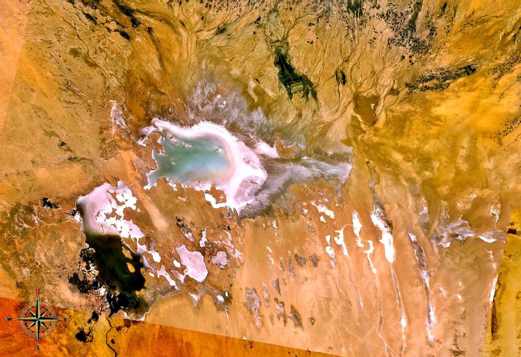
Chott Melrhir
Chott Melrhir, (Arabic: ???? ??????????) also known as Chott Melghir or Chott Melhir, is an endorheic chott-kind of salt lake in northeastern Algeria. It is the westernmost part of a series of depressions which extend from the Gulf of Gab??s into the Sahara. It was formerly known as Lake Tritonis. They were created between Miocene and Early Pleistocene as a result of compression accompanying the formation of the Atlas Mountains. With the maximum area of about 6,700 km2 (2,600 sq mi), it is the largest lake in Algeria. It lies almost entirely below sea level and contains the lowest point in Algeria, ???40 meters (???130 feet). Its size varies over the year and is usually larger than 130 km (81 mi) from east to west. The nearby cities are Biskra (60 km north-west), El Oued and Touggourt (85 km south). Hydrology, geology...
e: 2000000000000002097
Strings (13)
-
str_k__gdb_image
str.gdb:imagehttps://upload.wikimedia.org/wikipedia/commons/b/b4/Chott_Melrhir_NASA.jpg -
str_html_meta_format_detection
str.html:meta.format-detectiontelephone=no -
str_html_meta_generator
str.html:meta.generatorMediaWiki 1.44.0-wmf.8 -
str_html_meta_og_image
str.html:meta.og:imagehttps://upload.wikimedia.org/wikipedia/commons/b/b4/Chott_Melrhir_NASA.jpg -
str_html_meta_og_image_height
str.html:meta.og:image:height823 -
str_html_meta_og_image_width
str.html:meta.og:image:width1200 -
str_html_meta_og_title
str.html:meta.og:titleChott Melrhir - Wikipedia -
str_html_meta_og_type
str.html:meta.og:typewebsite -
str_html_meta_referrer
str.html:meta.referrerorigin -
str_html_meta_robots
str.html:meta.robotsmax-image-preview:standard -
str_html_meta_viewport
str.html:meta.viewportwidth=1120 -
str_k__rdfs_comment
str.rdfs:commentChott Melrhir, (Arabic: ???? ??????????) also known as Chott Melghir or Chott Melhir, is an endorheic chott-kind of salt lake in northeastern Algeria. It is the westernmost part of a series of depressions which extend from the Gulf of Gab??s into the Sahara. It was formerly known as Lake Tritonis. They were created between Miocene and Early Pleistocene as a result of compression accompanying the formation of the Atlas Mountains. With the maximum area of about 6,700 km2 (2,600 sq mi), it is the largest lake in Algeria. It lies almost entirely below sea level and contains the lowest point in Algeria, ???40 meters (???130 feet). Its size varies over the year and is usually larger than 130 km (81 mi) from east to west. The nearby cities are Biskra (60 km north-west), El Oued and Touggourt (85 km south). Hydrology, geology... -
str_k__rdfs_label
str.rdfs:labelChott Melrhir